The Central Meteorological Observatory predicts that from the second day of the Lunar New Year, the central and eastern parts of China will usher in rain and snow weather, and there will be strong cold air in the last three days of the Spring Festival holiday.
After the cold wave a year ago, the cold air receded. From January 30th to February 2nd, the warm and humid airflow will affect China from south to north, and the cold air encountered everywhere it goes will bring a large range of rain and snow to the central and eastern parts of China. It is expected that from January 30 to February 2, there will be light to moderate snow or sleet in eastern Gansu, southern Shaanxi, southern North China, Huanghuai, northern Jianghan and other places, including southern Shaanxi, northwest Hubei, western Henan, southwestern Shanxi, eastern Gansu and other places There is heavy snow and local blizzard, which is currently considered to be 10~15 mm, and the new snow depth is 2~5 cm, and the local snow is more than 8 cm.
The sleet or snow concentration period is from the night of the 30th to the 31st
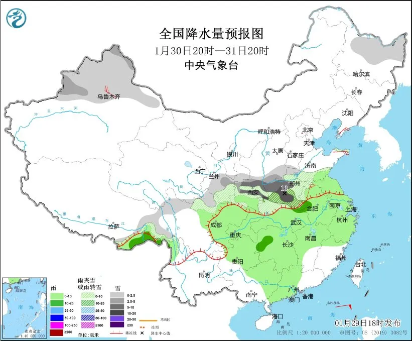
Image source: China Weather Network
There was light to moderate rain and locally heavy rain in most parts of the south, of which the main concentration of sleet or snow was from the night of the 30th to the 31st.
Compared with the large-scale rain and snow process a year ago, the range, intensity and duration of rain and snow were not as good as the previous one. The obvious snowfall is mainly concentrated in the southern part of Shaanxi, the western part of Henan and the high-altitude areas of Hubei, and the above areas are dominated by moderate to heavy snowfall, with local heavy snowfall. Due to the early warming, some of the above-mentioned areas will also experience the phase transition from rain or sleet to snow, and the phase of rain and snow is also relatively complex, and it is just in the temperature-sensitive area of rain and snow phase transition, and there is still a certain uncertainty in rain and snow.
This process will bring the expected heavy snow or rain to alleviate drought in the region, but heavier snowfall may occur at higher altitudes. Friends who have a plan to travel from high to high remember to pay attention to the latest meteorological and scenic management information, pay attention to walking safety when encountering ice and snow roads, and pay attention to the latest meteorological and road condition information when visiting relatives and friendsIn case of rain and snow, you need to slow down and pay attention to driving safety.
February 2-4
Stronger cold air will affect the central and eastern regions
After the end of the rain and snow process, from February 2 to February 4, there will be a strong cold air affecting the central and eastern regions, the temperature in most areas will drop by 4 °C – 6 °C, the eastern part of Northwest China, the western and northern parts of North China, the northeast region, the eastern part of Jianghuai, the eastern part of Jiangnan, South China and other places will drop by 6 °C – 8 °C, and the local drop of more than 10 °C in the northeast and other places.